![[Metroactive Features]](http://metroactive.com/features/gifs/feat468.gif)
[ Features Index | San Jose | Metroactive Central | Archives ]
Lost in Place
People pay to get lost--and find themselves
By Marina Wolf
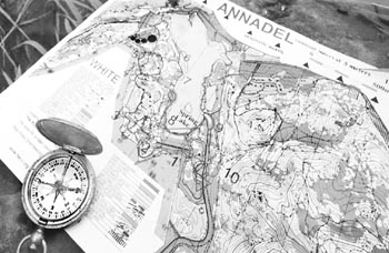
TEN MINUTES into the hike, and I'm already in trouble. The map and compass say go north, but there lies the steepest slope. The dry grass gives no traction on the forbidding hillside. I flash back to sixth-grade gym, when I couldn't get to the top of the rope but was too afraid of rope-burn to back down. With the temperature creeping into the mid-90s, the little water left in my bottle is getting warm. Some people call this fun. They also call it orienteering.
I call it hell.
Developed over 100 years ago in either Sweden or Norway (orienteers in both countries are fiercely at odds over this), orienteering was originally a training game for soldiers. Participants are given a detailed map, with elevations and contours carefully marked, and a list of directions to a series of brightly colored flags, or controls. The combination of map reading, compass watching and cross-country skills quickly became popular with civilians, and touched ground in the United States in the 1960s. And though its basic tools--a compass and a paper map--are retro to the point of anachronism, orienteering has kept up with the times. It will be an official event at next year's World Games in Japan; there are even professional orienteers in Europe who earn up to $200,000 a year from corporate sponsorships. Australian orienteering clubs host 24-hour courses, while others enthusiastically pursue Ski-O (on snow), Canoe-O (on the water), and even Street-O (imagine the fun wandering San Francisco alleys and hills!).
Even a normal orienteering expedition could justifiably be called "extreme." Consider the small print at the bottom of the event application, right after they ask for your age and car description: "You must return your card by two p.m., or a search and rescue effort will be initiated."
This should be my first warning, but I sign anyway and take a quick look around the well-groomed oak grove, where some 200 of us have gathered to have a go at orienteering in Spring Lake Regional Park. How tough can it be? The paths are heavily used and are bordered at several points by upscale housing developments. But poison oak and rattlesnakes lurk out there, says our cheerful welcome wagon of one, who is standing on a picnic table to be heard. "People in the white group don't need to worry, you'll be staying on the path. The yellow group"--my group--"well, just be careful."
Fortunately, the orienteering spirit seems to be more about comraderie than competition, at least in the lower divisions. There are so many of us following the same route that no matter how carefully the starters separate our departure times, we end up following each other. Anyway, none of us would get any points for stealth. The hard-core O-men (and a few women, too) have crashed off into the underbrush like elephants, and the cheery conversation of the older couple in front of me helps me find the second marker.
Right after that is where I get stuck on the hill. That's also where I met Al, a fast-talking fellow from Sacramento. "Hey, did you get the second control?" he asks as he scrambles up the slope.
"Yeah, but I don't think I'm going to get the third one," I say, peering ruefully up into the underbrush. He offers to scout out the territory. With the added encouragement and company, I manage to slowly pick my way up the hill behind him, feet sliding on the dirt, trying not to grab at low-growing shrubbery that may or may not be poison oak. (Note to self: Learn what poison oak looks like.)
At the top is what I hoped for: a dirt road that should lead us right to the next control, a quarry. Al at this point realizes that he lost his slip of paper listing the landmarks--the pros pin theirs to their shirts--and so a partnership is born.
We're not a very good team, for all that we get along. Both of us are beginners, and we both have the same vision problem. I'm not talking about glasses, either. It's simply that we're both products of our culture--we're both car drivers. We lack the necessary focus to really see our surroundings at a walking pace. It's an entirely different frame of reference, slowing the eye down from the frenetic, fast-forward pace and oversized perspective that defines the urban landscape. When you're used to signage that must be visible at 70 miles an hour, a slight jog in the path at 3 mph is too subtle to catch.
Then there's the confusion of terminology, especially baffling for city-dwellers such as me. What constitutes a pit? What is the difference between a large footpath and a small and poorly maintained dirt road? Oh, and I thought I knew what a quarry looks like: a gaping gouge in the earth. This was where our control No. 3 was supposed to be. After a half hour of wrong turns and backtracking, we find it, resting in something that might have been an ugly scar on the face of the earth 100 years ago, but now is just a mossy-walled alcove in the side of a hill.
"That's a quarry?" Al says loudly. I notice a group of Boy Scouts looking back at us.
Duh, their looks seem to say.
But the eye trains quickly. After the embarrassing quarry incident, I am able to match the landscape better to the scale of the map. And control No. 6 I find on my own, hanging limply on the north side of a boulder just off the path. I clamber quickly over the uneven ground, followed by Al and then two young girls and their mother.
But I am first.
Boosted by my first find, I take charge, marching us quickly down roads, into pits and through thickets. At No. 8, Al has to leave or miss his ride back to Sacramento, so I carry on alone for the next four searches. It's beautiful out here, once you get used to the crackling dry heat. Makes me wonder why it takes a story and a stopwatch to get me out onto the trail.
On my way to marker No. 10, I feel so calm that I almost forget to be amazed by the herd of deer that cuts across my path, including one with a huge rack of antlers. I've never seen a live deer with antlers.
A fellow orienteer jogs past in the opposite direction. He wears the uniform of the veteran--gloves, long-sleeved shirt and long pants of breathable nylon, hat with neck-protecting flap, and shoelaces strapped down with ragged duct tape. His gait is that of a marathoner: panting, sweaty, but steady as a rock.
I, too, am panting and sweaty, even though my route is half as long and half as steep, and I have walked the whole time. But I still experience a sense of exhilaration as I punch the 12th square on my sweat-sodden, dirty card at the finish line.
I place 22nd in the yellow group, just behind a group of Girl Scouts, finishing the 3.8-kilometer course (with a 110-meter rise) in two hours and 15 minutes. As usual, the numbers don't tell the whole story.
I finish by getting lost between the finish line and car--and coming down with a case of poison oak four days later.
[ San Jose | Metroactive Central | Archives ]
Copyright © 2000 Metro Publishing Inc. Metroactive is affiliated with the Boulevards Network.
For more information about the San Jose/Silicon Valley area, visit sanjose.com.
![]()
The next event of the Bay Area Orienteering Club takes place on Sunday, Sept. 10, at China Camp in San Rafael, with registration between 9am and noon. Entry fees are $6 per person, with discounts for groups; compass rental is $1. Visit the website at www.baoc.org, or call for details. 778.1604, 415.456.8188, or the Bay Area hotline at 408.255.8018.
From the September 7-13, 2000 issue of Metro, Silicon Valley's Weekly Newspaper.